


Brookgreen Voting District, Florence County, South Carolina
About
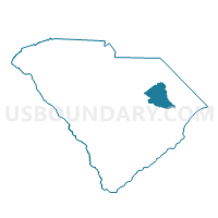
Outline

Summary
| Unique Area Identifier | 665699 |
| Name | Brookgreen Voting District |
| County | Florence County |
| State | South Carolina |
| Area (square miles) | 5.31 |
| Land Area (square miles) | 5.31 |
| Water Area (square miles) | 0.00 |
| % of Land Area | 100.00 |
| % of Water Area | 0.00 |
| Latitude of the Internal Point | 34.23896530 |
| Longtitude of the Internal Point | -79.78331680 |
Maps


Graphs
Select a template below for downloading or customizing gragh for Brookgreen Voting District, Florence County, South Carolina


Neighbors
Neighoring Voting District (by Name) Neighboring Voting District on the Map
- Back Swamp Voting District, Florence County, SC
- Florence Ward 10 Voting District, Florence County, SC
- Florence Ward 3 Voting District, Florence County, SC
- Palmetto Voting District, Darlington County, SC
- Quinby Voting District, Florence County, SC
- Spaulding Voting District, Florence County, SC
- West Florence 1 Voting District, Florence County, SC
- West Florence 2 Voting District, Florence County, SC
Top 10 Neighboring County Subdivision (by Population) Neighboring County Subdivision on the Map
Top 10 Neighboring Place (by Population) Neighboring Place on the Map
Top 10 Neighboring Unified School District (by Population) Neighboring Unified School District on the Map
Top 10 Neighboring State Legislative District Lower Chamber (by Population) Neighboring State Legislative District Lower Chamber on the Map
Top 10 Neighboring State Legislative District Upper Chamber (by Population) Neighboring State Legislative District Upper Chamber on the Map
Top 10 Neighboring 111th Congressional District (by Population) Neighboring 111th Congressional District on the Map
Top 10 Neighboring Census Tract (by Population) Neighboring Census Tract on the Map
- Census Tract 109, Darlington County, SC (7,095)
- Census Tract 113, Darlington County, SC (5,821)
- Census Tract 4, Florence County, SC (4,800)
- Census Tract 3, Florence County, SC (4,315)
- Census Tract 9, Florence County, SC (3,608)
- Census Tract 1.01, Florence County, SC (2,654)
- Census Tract 2.01, Florence County, SC (2,479)